Before
The Grid
The
1811 Plan
BUILDING
THE GRID
19TH-CENTURY
DEVELOPMENT
20th century–
Now
living on
the grid
other
Grids
19th-Century Development
Aerial View of Manhattan, 1921
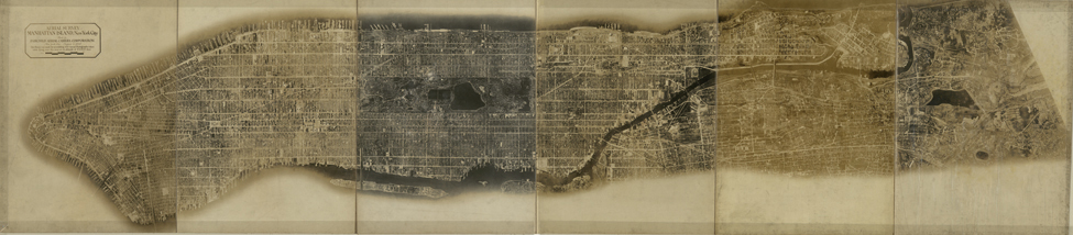

Lewis McSpaden for Fairchild Aerial Camera Corp., Aerial Survey of Manhattan Island, New York City, August 4, 1921
Library of Congress, Geography and Map DivisionPieced together from 100 aerial photographs, this 8-foot-long photomosaic of Manhattan demonstrates the full build out of the grid and its modified extension north of 155th Street. Taken on August 4, 1921, by Lewis McSpaden for the Fairchild Aerial Camera Corporation, this composite also highlights Central Park’s brilliant relationship with the grid, at once deferring to the grid’s overarching organizational principles but creating a sharply contrasting pastoral landscape. Central Park had become an 843-acre oasis on an island with little other open space, its terrain sealed off from the rest of the city by a continuous street wall of buildings. Although this site was chosen for the park in part because the rocky land there was cheaper to acquire and more difficult to develop than in the other neighborhoods initially proposed, the park’s location in the middle of the island offers a practical symmetry, as if it were predetermined by the 1811 plan itself. CY