Before
The Grid
The
1811 Plan
BUILDING
THE GRID
19TH-CENTURY
DEVELOPMENT
20th century–
Now
living on
the grid
other
Grids
19th-Century Development
The Galt-Hoy Map, 1879
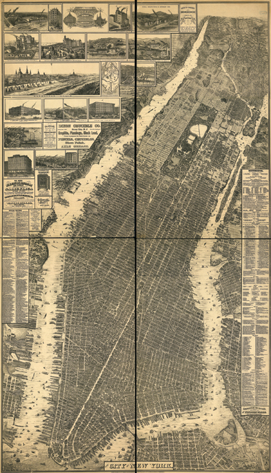


“The City of New York,” William L. Taylor, chief draftsman, published by Galt & Hoy, 1879
Library of Congress, Geography and Map DivisionWhile not the first bird’s-eye view of New York, this map, drafted by William L. Taylor, significantly advanced the genre’s representation of Manhattan. By using an oblique perspective from an apparent altitude significantly higher than its predecessors, Taylor’s mammoth wall map encompasses the entire island, a metropolis in the midst of a period of rapid growth. The population had doubled in the previous 30 years; in 1879 it exceeded 1 million. Taylor documents this growth in staggering detail. Intensive real estate speculation and development charged northward, particularly, along the rail transportation corridors as the map indicates, along the Upper East Side and in Harlem.
By contrast, the Upper West Side is relatively undeveloped. Typical of mid-19th-century bird’s-eye views, the map illustrates important industrial and leisure sites in the top left corner, and listings of prominent businesses flank the sides. This visually busy work portrays a huge variety of ships steaming and sailing, factories smoking, and rail tracks both on the ground and elevated, for streetcar, commuter train, and commerce weaving together this densely packed urban fabric. MK