Before
The Grid
The
1811 Plan
BUILDING
THE GRID
19TH-CENTURY
DEVELOPMENT
20th century–
Now
living on
the grid
other
Grids
Living on The Grid
Address Calculator
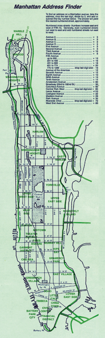

“Manhattan Address Finder,” New York City 5 Borough Atlas, 3rd ed., Hagstrom Map Company, Inc., 1994
© Kappa Map Group LLC, (800) 829-6277. Used with permissionIn Manhattan, the grid makes it easy to locate addresses on the cross-streets, because the numbering starts at Fifth Avenue and increases as one moves east or west toward the rivers. Building numbers increase by one hundred at every long block, so the Times Square Building at 229 West 43rd Street, for example, is on the third block west of Fifth Avenue.
Locating addresses on the avenues can be much more complicated. When the grid was laid out in 1811, each avenue had a different starting point depending on how far north the city had developed in that area of the island. As a result, the numbering systems for the avenues do not align with each other, so the Empire State Building at 350 Fifth Avenue is between 33rd and 34th Streets while the same address on Seventh Avenue is between 29th and 30th Streets.
Determining the cross-street for an avenue address requires an algorithm. For most avenues, it is possible to take the building number, divide by twenty, and then add or subtract an integer specific to that avenue and come up with the cross-street. For Lexington Avenue, the integer is 22, for Park Avenue it is 35. Most avenues have a single integer that applies to their entire length, but there are also exceptional cases where different integers apply to different sections of the street, including Fifth Avenue and Broadway.
Before smartphones made the whole system obsolete, algorithms for the different avenues were printed in telephone books, in city guidebooks and maps, and on wallet-size cards to help both residents and visitors alike locate addresses on the grid. CY