Before
The Grid
The
1811 Plan
BUILDING
THE GRID
19TH-CENTURY
DEVELOPMENT
20th century–
Now
living on
the grid
other
Grids
Before the Grid
Ground Conditions: British Headquarters Map
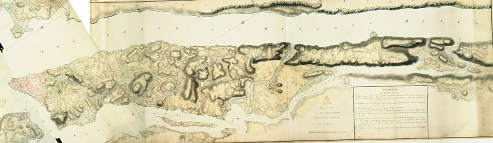

British Headquarters Map, plans 1 and 2 of New York, Long Island, Hudson River, East River, showing British and American fortifications, ca. 1782
Courtesy The National Archives, United Kingdom, MR 1/463This map, drawn by British military cartographers toward the end of the American Revolution, shows the farms, country roads, isolated homesteads, fortifications, and the “town of New York” (in pink blocks on the left) in 1782 or 1783, but it is most precious as a record of the varied geography of the island. It is colloquially called the “British Headquarters Map,” as an American antiquarian, B. F. Stevens, thought it hung in the British military headquarters in the Old City Hall during the war. Given its size, 37½ x 125 inches, and scale, 6 inches: 1 mile, it is easy to imagine it hanging there, the culmination of the hundreds of maps drawn by British engineers to help plan the defense of Manhattan against the rebels who buzzed around the loyalist city and British encampments.
An ecologist, Dr. Eric Sanderson of the Wildlife Conservation Society, saw a reproduction of the map, and it spawned an investigation into all that preceded the grid—not only the farms, country roads, and colonial town, but also the streams, beaches, wetlands, and hills of the place that the native Lenape Indians called Mannahatta, the “island of many hills.” This is told in Sanderson’s book Mannahatta: A Natural History of New York City (2009). ES