Before
The Grid
The
1811 Plan
BUILDING
THE GRID
19TH-CENTURY
DEVELOPMENT
20th century–
Now
living on
the grid
other
Grids
Building the Grid: From Paper to Street, Block and Lot
Beekman’s Estate: Subdivision Plan
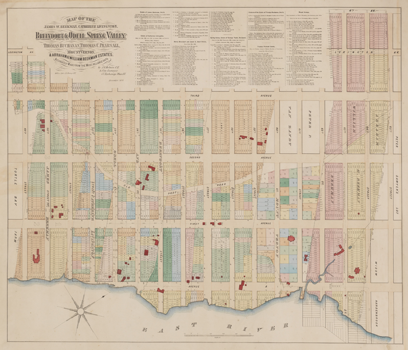


“Map of the James W. Beekman, Catherine Livingston, Breevoort & Odell, Spring Valley, Thomas Buchanan, Thomas C. Pearsall, Mount Vernon, & Abraham and William Beekman Estates,” Lexington Avenue to the East River, 49th to 65th Streets, compiled by John Bute Holmes, 1870
George Glazer GalleryElements of both the old and new city plan can be seen in the area north of Turtle Bay on this map of 1870. The large farms and estates—those belonging to the Beekmans, Breevoorts, Odells, and others—have been divided into rectangular city blocks, but the winding path of the Old Post Road remains present.
The text at the top of the map describes how various properties changed hands over time, whether conveyed to family members or sold to new owners. In the late 1830s, James W. Beekman inherited his family’s estate by the East River and became a prolific real estate developer. When streets were graded through his property, he divided his estate into lots and transformed it into a residential neighborhood, even helping prospective buyers finance their purchases.
The grading of 51st Street forced Beekman to move Mount Pleasant, his family’s home, around 1850. As seen on the map, he placed the house north of 50th Street, on a bluff with views over the East River. Today the area is known as Beekman Hill. AR