Before
The Grid
The
1811 Plan
BUILDING
THE GRID
19TH-CENTURY
DEVELOPMENT
20th century–
Now
living on
the grid
other
Grids
Building the Grid: From Paper to Street, Block and Lot
Surveying the City
Transferring the straight lines of the 1811 plan from paper to terrain was a demanding process. It did not require unusual technical skills; measuring straight lines across a limited distance was basic to the surveyor’s art. But the social context, human interference, and need for legally binding precision complicated the grid surveys.
This effort was led by John Randel, Jr. over a period of 14 years, from 1807, when the commissioners appointed him as their secretary and surveyor, to 1820, when he completed a detailed atlas of the island. Read More Randel’s first wave of surveying informed the 1811 plan: his work is reflected in the elevation notations, the varying distances between the avenues, the unvarying 200-foot width of the blocks, and the hierarchy of street widths. In the next phase of work for the Common Council, Randel meticulously resurveyed the island, placing stone monuments at the location of future streets and recording the properties and natural features that the grid would have to reorganize.
His careful measuring was conducted amid protests and litigation. Randel’s surveyors were regularly obstructed, attacked, and sued for damages for cutting branches to complete their work. Randel himself was often arrested for trespassing. But in short order, the streets he surveyed became sought-after improvements. Looking back at his survey work 20 years later, Randel commented: “The persons who instituted those suits were a few of the numerous opponents of the field operations of the Commissioner, which included their property in the then new Plan for the city, many of whose descendants have been made rich thereby.” Show Less
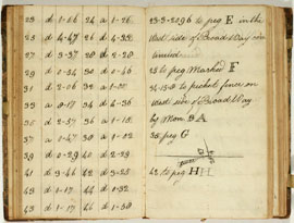
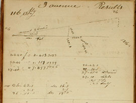
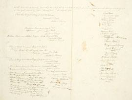
The process of accurately determining block length was quite involved. These pages from an 1811 field book show measurements of angles of ascent and descent, apparently... Read More
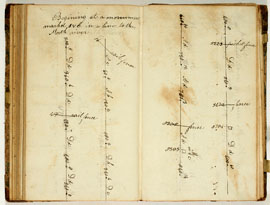
This page is headed by Randel’s note: “Beginning at a monument marked FVC” [and continuing] “in a line to the North river.” Randel is here surveying a future street from... Read More
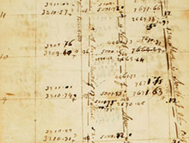
Randel’s thoroughness is on display on this page that shows him double-checking measurements to assure that the avenues are straight and parallel. On the left page... Read More
Randel took pride in the precision of his instruments and the resulting measurements. Here he adjusts a chain. “Friday February 9th. The chain on being examined is found... Read More
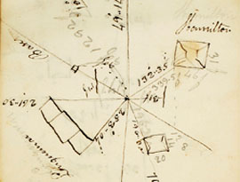
The top page of this spread shows a diagram where Randel notes a crucial distinction in surveying. When a surveyor plumbs up his sighting device and looks forward... Read More
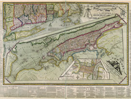
This map is a testimonial to Randel’s surveying art. He organized the picture as three superimposed maps, with the gridded island of New York placed in a regional... Read More
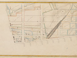
The farm maps, as they have come to be called, drawn up by John Randel, Jr., portray early-19th-century Manhattan in stunning and rare detail, at a scale of 100 feet to... Read More
The first in the series of farm maps portrays the origin, or baseline, of the 1811 grid plan, which was to start north of North Street, now Houston Street. Read More
The Manhattan surveys led by Randel required a large crew of men to stretch chains or rods to measure distance, axe men to chop trees or shrubs to clear a line of sight... Read More
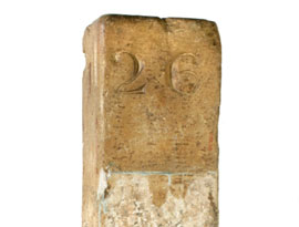
The 1807 act of the New York State Legislature instructed the commissioners to erect “suitable and durable monuments at the most conspicuous angles.” These locations... Read More
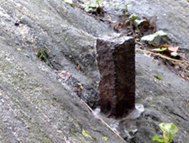
The 1807 act of the New York State Legislature instructed the commissioners to erect “suitable and durable monuments at the most conspicuous angles.” These locations... Read More
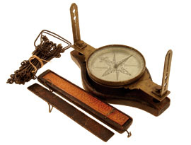
This surveyor’s compass from the late 1700s, its sighting vanes disassembled, is placed in a sturdy wooden case, ready to be carried out into the wilderness. Read More
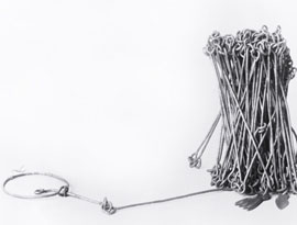
Before the early 20th century, a surveyor would use a chain to make measurements. This chain, from the 1830s, was owned by John Johnson, the Surveyor General of Vermont... Read More
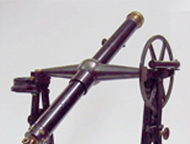
The best tool for finding true north is a geodetic transit like this one from the early 1800s. These transits are large instruments—some as tall as a person—featuring... Read More
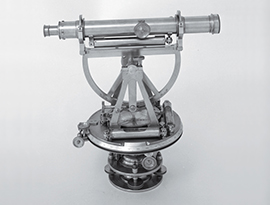
A primary job of a surveyor’s sighting device is to turn angles; that is, from a reference direction, to rotate the device’s sights a precise number of degrees so that... Read More