Before
The Grid
The
1811 Plan
BUILDING
THE GRID
19TH-CENTURY
DEVELOPMENT
20th century–
Now
living on
the grid
other
Grids
Building the Grid: From Paper to Street, Block and Lot
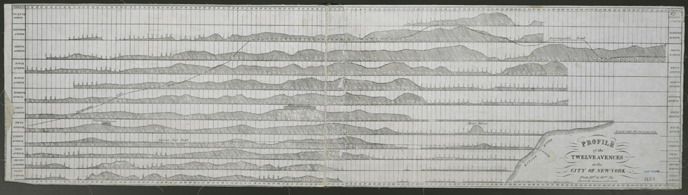
Profile of the Twelve Avenues


Map of the Twelve Avenues in the City of New York, compiled for D.T. Valentine’s Manual, 1850
The Lionel Pincus and Princess Firyal Map Division, The New York Public Library, Astor, Lenox and Tilden FoundationsThe profiles of Manhattan’s historical topography along its major avenues are shown here in a map compiled by George Hayward for Valentine’s Manual in 1850. The rugged terrain of Manhattan’s West Side and the low-lying Harlem Plains on the East Side are particularly evident. It is often assumed that the historical elevations along these profiles were flattened to make way for the grid. However, when one compares the historical and contemporary elevation profiles for Manhattan’s avenues, the difference is actually not as dramatic as one might suppose. Most locations along Manhattan’s avenues only witnessed modest elevation changes, although some areas experienced considerable topographic alterations. For instance, elevations near the intersection of First Avenue and 41st Street dropped nearly 40 feet as a result of street construction, and some elevations on the West Side changed by as much as 118 feet. The majority of elevation changes, however, were less than 10 feet. Consequently, topographic maps of the elevation profiles for Manhattan’s avenues today show a remarkably similar pattern of topographic variation to that depicted in Hayward’s map from the mid-19th century. RR