Before
The Grid
The
1811 Plan
BUILDING
THE GRID
19TH-CENTURY
DEVELOPMENT
20th century–
Now
living on
the grid
other
Grids
Building the Grid: From Paper to Street, Block and Lot
John Randel’s Surveying Notes: The Slope of Third Avenue
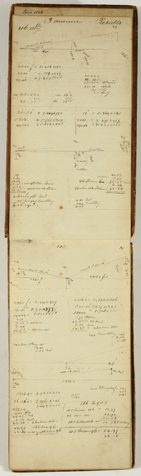


John Randel, Jr., Results of Levels, vol. 61.3, 1817
Collection of the New-York Historical Society, #84730dThe top page of this spread shows a diagram where Randel notes a crucial distinction in surveying. When a surveyor plumbs up his sighting device and looks forward, he is facing a direction represented by the level line shooting outward from point B. But the surface of the earth is actually curving downward from where the surveyor stands, an effect shown in exaggerated fashion by the arc Randel has drawn “from the center of the earth.” When measuring the usual farm plots of the 19th century, this difference hardly came into play. But when a survey extends northward for a full eight miles, as was the case with the Manhattan grid, the difference starts to matter.
On the opposite page Randel explains his rule for addressing this curvature of the earth, specifically in his method of measuring along Third Avenue from 96th to 116th Street. He remarks that the “Curvature to be allowed in leveling is the difference between the radius and sexant of the Triangle. Radius being the earth’s semi-diameter.” Many measurements follow. BH