Before
The Grid
The
1811 Plan
BUILDING
THE GRID
19TH-CENTURY
DEVELOPMENT
20th century–
Now
living on
the grid
other
Grids
The 1811 Plan
Simeon De Witt
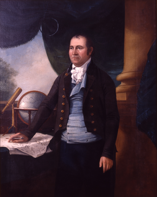

Ezra Ames, Portrait of Simeon De Witt, ca. 1804. Oil on canvas, 168 x 137.5 cm
Collection Zimmerli Art Museum at Rutgers University, Gift of the Grandchildren of Simeon De Witt, 0016. Photo by Jack AbrahamTrained in surveying as a youth, Simeon De Witt (1756–1834) gained early distinction making maps for George Washington during the Revolution, ultimately becoming Geographer and Surveyor of the Continental Army. After the war, De Witt settled in Albany, where he served for a half century until his death as the surveyor general of New York State. His 1802 state map set a standard for American cartography. De Witt declined appointment as surveyor general of the United States (1796), but while serving on the Manhattan street commission he eagerly accepted a position (1810) on the first state commission exploring a cross-state canal to Lake Erie.
De Witt’s unrivaled mapping and surveying experience made him a logical choice for the street commission. Given his extensive record laying rectilinear grids elsewhere in the state, De Witt was the likeliest among the commissioners to propose and promote a regular grid for Manhattan. De Witt was responsible for the hiring of his likeminded young Albany protégé, John Randel, Jr., to serve as the commission’s chief surveyor. GK