Before
The Grid
The
1811 Plan
BUILDING
THE GRID
19TH-CENTURY
DEVELOPMENT
20th century–
Now
living on
the grid
other
Grids
Other Grids
Savannah
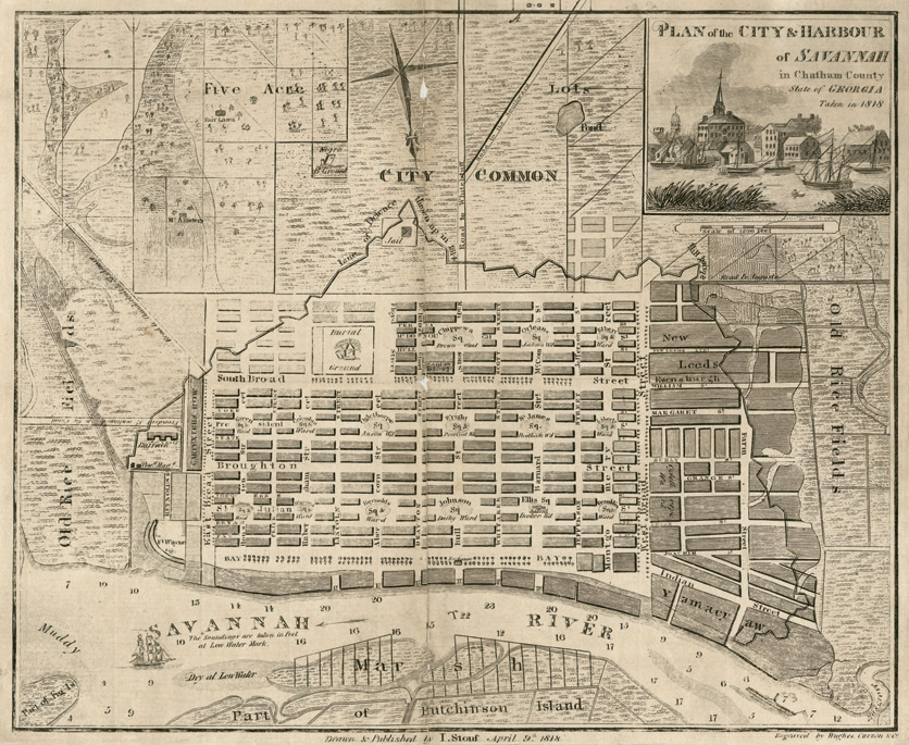


“Plan of the City and Harbour of Savannah in Chatham County, State of Georgia,” 1818. Drawn and published by I. Stouf; engraved by Hughes Curzon & Co.
Hargrett Rare Book and Manuscript Library, University of GeorgiaKing George II granted a new colony to The Trustees of Georgia in 1732. The chief trustee, James Oglethorpe, chose the site of the first settlement and devised a complex plan for apportioning the town. Following the usual practice for port cities, he laid out Savannah parallel to the riverfront, but his unique idea was to divide the town into wards, each centered on its own small park. Straight streets, up from the waterfront, would penetrate the wards, but in a particular manner: half of the streets would pass by the wards, bordering them, but the other streets would be interrupted by the parks. If Penn’s Philadelphia plan presented the problem of too-large blocks that needed to be subdivided, Oglethorpe’s Savannah plan has had the opposite effect: the street pattern has made it difficult to assemble large parcels by combining blocks.
The wards were further divided into two kinds of blocks. Long, thin blocks, called tything blocks, were divided into small house lots backing up onto a shared alley. Facing the park on either side were four large trust blocks, left undivided and intended for grand homes and institutions. Only a few wards were built before the trustees lost possession of the colony, but the people of Savannah were so pleased with the ways of life allowed by Oglethorpe’s grid that they continued to lay out new wards until the end of the 19th century. The Stouf plan shows the city in 1818, with 15 wards. BH