Before
The Grid
The
1811 Plan
BUILDING
THE GRID
19TH-CENTURY
DEVELOPMENT
20th century–
Now
living on
the grid
other
Grids
Other Grids
Law of the Indies
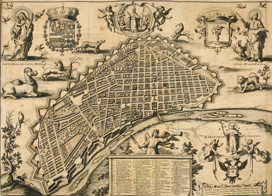

Joseph Mulder, view of Lima, in Francisco de Echave y Assu, La Estrella de Lima convertida en sol sobre sus tres coronas (Amberes: J.B. Verdussen, 1688)
Public domainThis bird’s-eye view over Lima shows the core of the city founded by Francisco Pizarro on January 18, 1535, on a site previously occupied by the Inca empire. The Spanish often located their cities on indigenous settlements in order to establish dominion over the population and to take advantage of existing infrastructure. The regular street grid formed a crucial part of their strategy: it effaced previous organizational systems and divided the land into even plots that could be quickly reassigned to new settlers.
In planning Lima, Pizarro followed the Laws of the Indies, instructions of Charles V (1500–1558) concerning colonial settlements. They concerned every aspect of colonial rule, including the treatment of native populations, and contained specific regulations about the use of the grid as an agent of control that allows for rapid implementation and expansion of the city.
The street grid of Lima is known as the damero de Pizarro (Pizarro’s draftboard) because he personally helped mark off the lines of the streets with a ruler and cord. It had square blocks, 400 feet per side, arranged 13 blocks by nine blocks with 40-foot-wide streets. In this view, an open square with a fountain in the middle is visible near the bridge across the river. Another essential feature of Spanish colonial settlement, the square is the site of the major civic and religious buildings.
The Spanish replicated the pattern exemplified by Lima in hundreds of towns and cities, including Santa Domingo, Panama City, Mexico City, Veracruz, Cartagena, Valparaiso, Bogotá, Santiago, and Buenos Aires. CY