Before
The Grid
The
1811 Plan
BUILDING
THE GRID
19TH-CENTURY
DEVELOPMENT
20th century–
Now
living on
the grid
other
Grids
Before the Grid.
The Goerck Plan of the Common Lands, 1796
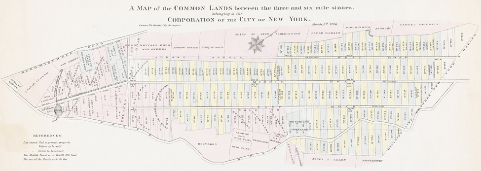


Casimir Goerck, A Map of the Common Lands between the three and six mile stones belonging to the Corporation of the City of New York, 1796 (as reproduced in 19th century)
Museum of the City of New York, The J. Clarence Davies Collection, 29.100.3034The municipality’s landholdings, known as the Common Lands, encompassed about two square miles in central Manhattan, from today’s 23rd to 90th Street between Second and Seventh Avenues. In 1785, city officials hired Casimir Theodor Goerck to divide the land into lots for lease or sale, in order to raise revenue to pay off New York’s Revolutionary War debt. (The 1785 plan does not survive.) In 1796, the city had Goerck revise his subdivision plan, and he produced the first extensive rectangular plan of the island. (It is only known through 19th-century copies.)
Goerck structured five-acre, rectangular lots that were alternately designated for sale or lease with the rationale that sold lots would raise the value of leased lots that could later be sold at higher prices. The lots were organized by three long, parallel streets, which he called East, Middle, and West Streets, but Goerck’s plan did not entail a street system, let alone a comprehensive vision for the city. His plan was intended to expedite the sales of large tracts of land, not to organize a fast-growing city.
Goerck’s 1796 map can be read as the genesis of Manhattan’s geometric order. In a generation, his lots became the Grid Commission’s five-acre blocks, and East, Middle, and West roads became Fourth, Fifth, and Sixth Avenues. GK