Before
The Grid
The
1811 Plan
BUILDING
THE GRID
19TH-CENTURY
DEVELOPMENT
20th century–
Now
living on
the grid
other
Grids
Modern Reforms, 20th Century—Now
Map of Mid-Block Arcades
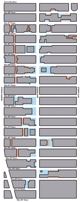

Privately-owned public spaces and the Manhattan street grid: plazas and arcades in central Midtown, 2011, based on the data of Jerold S. Kayden
Created by Carolyn YerkesThe cumulative effects of the 1961 Zoning Resolution can be seen in this map of the two-block zone between Fifth and Seventh Avenues from Central Park South to 40th Street, which shows all the plazas (blue) and arcades (orange) that have been built since the resolution’s passage. In an effort to emphasize the effect of the zoning resolution on midtown Manhattan, public spaces built before 1961, such as the plazas around the Time & Life Building on Sixth Avenue between 50th and 51st Streets, are not shown.
The data for this map were compiled by Jerold S. Kayden, a professor of urban planning and design at Harvard University who, in conjunction with the New York City Department of City Planning and the Municipal Art Society of New York, published an exhaustive study of the privately owned public spaces built under the 1961 Zoning Resolution. Above all, the map illustrates how the succession of public plazas created along Sixth Avenue has erased the street wall there and how the addition of mid-block arcades between Sixth and Seventh Avenues has added a de facto secondary street to the 1811 grid. CY