Before
The Grid
The
1811 Plan
BUILDING
THE GRID
19TH-CENTURY
DEVELOPMENT
20th century–
Now
living on
the grid
other
Grids
19th-Century Development
Collage of Public Parks, 1838
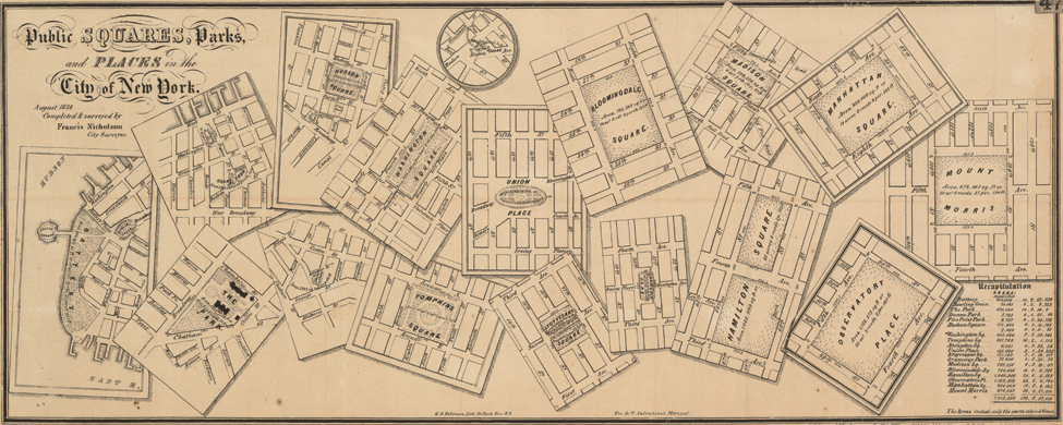

Map showing public parks in New York City, 1838. Lithograph
Historic Maps Collection. Department of Rare Books and Special Collections, Princeton University LibraryThe lithograph presents a collage of scattered maps depicting all of New York’s public places in 1838. It highlights that New York deviated from the Commissioners’ Plan in its development by becoming a city of neighborhood parks and squares in the first half of the 19th century. On the left are the small public spaces that existed in lower Manhattan before 1811. In the 1811 plan, the commissioners primarily laid out larger public places that took up multiple blocks in the “empty” northern reaches of the island. Only Union Place and a large market were laid out close to the city’s residents.
As seen in the middle of the collage, New York officials altered this plan as the city grew by establishing smaller and more numerous parks downtown in order to address the deficiency of open spaces in the area. In part guided by the initiative of a few enterprising individuals, New York officials opened Washington, Tompkins, and Stuyvesant Squares as well as Gramercy Park—new spaces that adhered to the grid’s rectangular plan.
Few of the public squares and places established in the 1811 plan were actually built. By 1838 Harlem Square had already been eliminated in favor of Mount Morris Park, and city officials had redesigned Union Place and shrunk the Grand Parade into Madison Square. Some of the commissioners’ northern spaces were still on the map: Manhattan, Hamilton, and Bloomingdale Squares, and Observatory Place—but only Manhattan Square was ever opened. The other three spaces were abolished after the creation of Central Park. By the 1850s, the city’s strategy of small neighborhood open spaces no longer sufficed to accommodate its growing population, leading to the establishment of its single, great public space, Central Park. AR