Before
The Grid
The
1811 Plan
BUILDING
THE GRID
19TH-CENTURY
DEVELOPMENT
20th century–
Now
living on
the grid
other
Grids
19th-Century Development
Green’s Reforms for Northern Manhattan, 1868
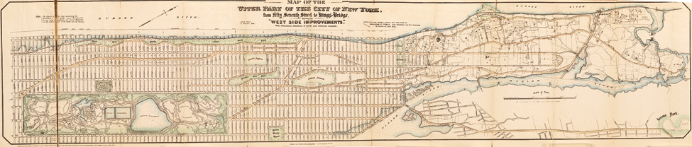

“Towle’s Map of the Upper Part of New York City, West Side Improvements,” 1868
Museum of the City of New York, The J. Clarence Davies Collection, 29.100.2723In 1868 city surveyor Hamilton E. Towle created this map to illustrate the Central Park Commission’s redesigns for the areas north and west of Central Park. Scientific American described the map as “a valuable guide to persons desiring to purchase desirable lots in this Babylon of the Western Hemisphere,” a comment that linked the improvements to real estate speculation.
Highlighted in green and brown, the map displays two of comptroller Andrew H. Green’s major replanning ideas for the region: a series of large public parks running up the West Side and a system of boulevards linking Central Park to the spectacular natural landscape of Manhattan’s upper arm.
Green’s West Side improvements include the establishment of Riverside Park along the Hudson River, Morningside Park, and Convent Grounds (today St. Nicholas Park). These curvy and irregular parks were planned according to new ideals and conform to the area’s natural topography rather than to the orthogonal grid. They contrast with the island’s rectangular green spaces also illustrated on the Towle Map: Central and Mount Morris Parks; Manhattan Square, which Green planned to develop as a Zoological Garden; the Lunatic Asylum, which became the Columbia University campus in 1896; and Trinity Cemetery.
“New Avenues,” still unnamed, wrap around Green’s parks and adhere to the topography of the upper part of Manhattan. Sixth and Seventh Avenues have been widened; the new St. Nicholas Avenue runs on a diagonal from the north of Central Park; and a network of thoroughfares extend through the West Side and loop around the top of the island. The most prominent of these was the Boulevard, which Green laid out from the Circle at 59th Street, to 155th Street, at times following the wiggling path of Bloomingdale Road, depicted here in faint dotted lines. AR