Before
The Grid
The
1811 Plan
BUILDING
THE GRID
19TH-CENTURY
DEVELOPMENT
20th century–
Now
living on
the grid
other
Grids
The 1811 Plan
The Bridges Map, 1811
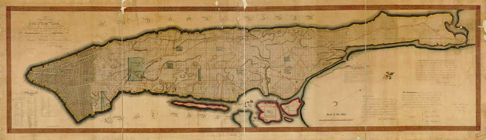


Image 4
This map of the city of New York and island of Manhattan, as laid out by the commissioners appointed by the legislature, April 3d, 1807 is respectfully dedicated to the mayor, aldermen and commonalty thereof by their most obedient servant Wm. Bridges, city surveyor; engraved by P. Maverick, 1811. Line engraving on copper
Library of Congress, Geography and Map DivisionIn November 1811, seven months after Randel filed his three official drawings, William Bridges published a print copy. It is unclear how he gained access to the information; in Randel’s eyes, Bridges stole his work. Randel was understandably vexed: Bridge’s printed map provided the first public glimpse of the future city. Today the map is rare; Isaac Newton Phelps Stokes, New York’s great iconographer in the early 20th century, counted only 10 surviving copies.
Whereas Randel’s map is a measured survey, Bridges’s map is a colorful picture that evokes the physical reality of the city—its buildings, landscape, and docks as well as the populated area of the city, which is shaded.
© 2015 Museum of the City of New York all rights reserved