Before
The Grid
The
1811 Plan
BUILDING
THE GRID
19TH-CENTURY
DEVELOPMENT
20th century–
Now
living on
the grid
other
Grids
Other Grids
Melbourne, Australia, 1837
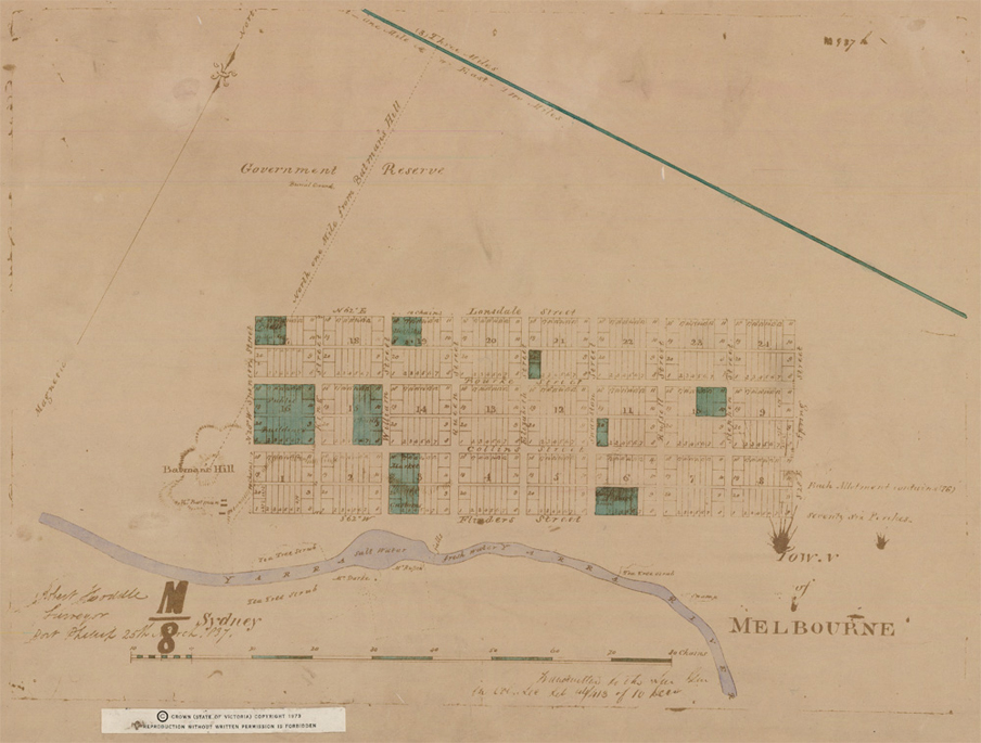


Robert Hoddle’s grid plan for the town of Melbourne (shown within the surrounding terrain of the Port Phillip District), 1837
PROV, VPRS 8168/P2 Historic Plan Collection, Unit 6166, Sydney M8, Town of Melbourne. © State of Victoria through Public Record Office Victoria. Reproduced with the permission of the Keeper of Public Records, Public Record Office Victoria, AustraliaAfter the first British expedition in 1835, Melbourne was named by its British settlers in 1837, the date when this manuscript plan of the town was drawn by surveyor Robert Hoddle. Located on the bank of the Yarra River, the town is envisioned as a grid of 24 rectangular blocks, each bisected by a lane that services the back of the lots. The street system has a clear hierarchy: narrow lanes running east-west, parallel streets of greater width, and even wider perpendicular streets, whose primacy is reinforced by the square lots that face onto them. Otherwise the lots are narrow rectangles, akin to those of the Manhattan grid. The plan projects an idea of compact settlement, with adjacent buildings on small town lots and an expandable system able to accommodate population growth as needed.