Before
The Grid
The
1811 Plan
BUILDING
THE GRID
19TH-CENTURY
DEVELOPMENT
20th century–
Now
living on
the grid
other
Grids
Building the Grid: From Paper to Street, Block and Lot
Assessment map of Madison Square
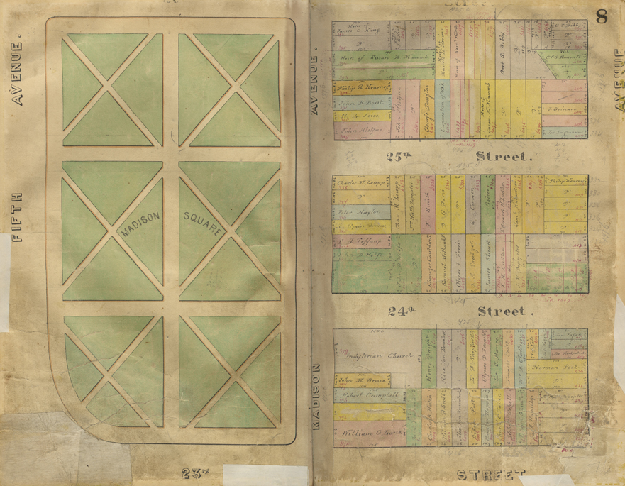


Assessment map of Madison Square from 18th Ward, Volume I, 1853–1879
New York City Municipal ArchivesThe city used this volume of colorful assessment maps to maintain records of property values and locations for tax purposes. Until the 1820s, the municipal corporation filled its treasury by renting property, including its common lands and wharves, and by collecting license and franchise fees. Property taxes were originally low, but increased as land prices rose. The city’s growing reliance on real estate taxes motivated officials to improve property values by opening streets and parks as a means to collect more money for the municipality. In 1830 property tax revenue amounted to roughly $200,000, but seven years later, it totaled $1.1 million.
The open pages depict the original landscaping of Madison Square. Penciled additions update changes in ownership and lot lines. Land values were much higher and homes were more luxurious facing Madison Square than along Fourth Avenue. In 1860 real estate along Fourth Avenue in the section depicted ranged from $3,500 to $8,000, while lots along Madison Avenue were valued between $18,000 and $55,000. The lot with house number 413 on Fourth Avenue, between 24th and 25th Streets, colored gray on the map, was owned by Mr. Sinclair and valued at $6,000. Directly across, on Madison Avenue, a similarly sized lot shaded pink, with a larger home owned by Mr. Tiffany, was valued at $20,000. AR