Before
The Grid
The
1811 Plan
BUILDING
THE GRID
19TH-CENTURY
DEVELOPMENT
20th century–
Now
living on
the grid
other
Grids
19th-Century Development
Gramercy Park and Lexington Avenue: Samuel Ruggles’s Property, 1831
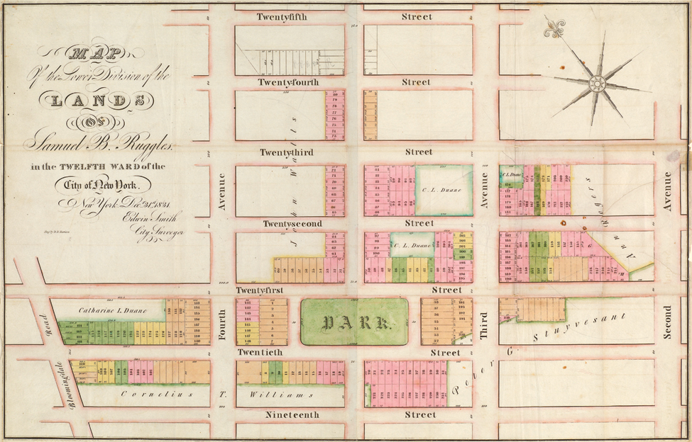


Edwin Smith, “Map of the Lower Division of the Lands of Samuel B. Ruggles in the Twelfth Ward of the City of New York,” December 31, 1831. Engraving by D.R. Harrison
Samuel B. Ruggles papers, Manuscripts and Archives Division, The New York Public Library, Astor, Lenox and Tilden FoundationsThis December 1831 map of Samuel B. Ruggles’s land illustrates the developer’s vision: a rectangular green park and new avenue are the centerpiece of his real estate enterprise. The document also suggests the hard work necessary to execute such an ambitious plan. The contours of his property are irregularly shaped, revealing how he patched together the land from a variety of owners, a process that took most of 1831 to accomplish. Most of his property is right angled, in line with the city’s new streets and lot dimensions. Ruggles did not purchase the land in this shape; old property lines did not conform to the Commissioners’ Plan. To the east, where Ruggles’s holdings abut those of Peter Stuyvesant and Anne Rogers, one can see the results of a typical purchase of land for the period. The oblique boundaries of old farm lines create odd, triangular lots that were more difficult to sell. Ruggles was able to adjust his property and make it fit into the city’s rectangular plan by trading slivers of land with neighbors, such as Catherine L. Duane, who still retained some property along 22nd Street. The map also shows why Ruggles placed Gramercy Park to the south of his property, between 20th and 21st Streets: it was the only location where it could be completely surrounded by his own property. AR